 AuSable River Maps |
|
AuSable River Maps |

MIO to 4001 Bridge Designated National Wild and Scenic River section Campsites. Several launch sites. Length: 23.11 miles SEMI-PRIMITIVE NON-MOTORIZED AREARemote river section between Alcona Dam and Loud Pond Campsites One launch site 
LOUD POND A quiet natural area Campsites One launch site. Length: 5.1 miles 
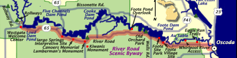
FIVE CHANNELS POND Campsites One launch site Length: 3 miles
COOKE POND Islands with campsites, shoreline campsites, Iargo Springs, Lumberman's Monument, The Highbanks, etc. Several launch sites. Length: 7.9 miles
FOOTE POND Islands and excellent fishing Campsites Several launch sites. Length: 10 miles
LOWER AuSABLE Mainstream flowing to Lake Huron river mouth Campsites. Two launch sites Length: 12.3 miles   | AuSable River Maps | AuSable River Canoe Marathon | | BOATS and EQUIPMENT | Kayaking Photo Gallery | Canoeing Photo Gallery | Canoe Country Nature Gallery | Kayaking Lake Huron | AuSable River Canoe Area | | Return Home | Clothing & Outerwear | Footwear | Cross Country Skiing | Kayaking & Canoeing | Tawas Bird & Nature Observation | Fly Fishing | Corsair Ski Trail Conditions | Hiking & Backpacking | Events Schedule | Links | Contact Us | Employment | |
||